Geolocate

Chowk topographic map

Click on the map to display elevation.

About this map

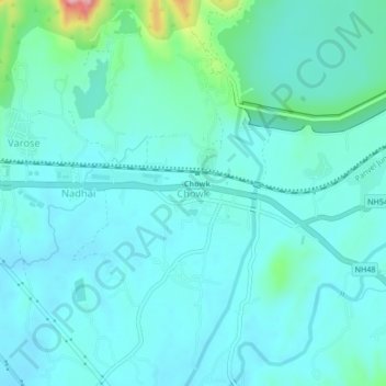
Name: Chowk topographic map, elevation, terrain.

Location: Chowk, Khalapur, Raigad District, Maharashtra, India (18.88055 73.21979 18.92055 73.25979)

Average elevation: 53 m

Minimum elevation: 25 m

Maximum elevation: 208 m

Gear up for your next adventure:

🛶Kayak Dry Bag - Waterproof storage for kayaking adventures
🔭Compact Monocular - One-handed bird watching and trail spotting
🎒Backpack Rain Cover - External shield to keep your entire pack dry
🩹Moleskin Blister Pads - Direct protection for painful foot pressure points
🥾Hiking Leggings - Comfortable leggings for outdoor activities

As an Amazon Associate, this site earns from qualifying purchases at no extra cost to you.