Geolocate

Jabalpur topographic map

Click on the map to display elevation.

About this map

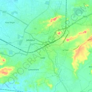
Name: Jabalpur topographic map, elevation, terrain.

Location: Jabalpur, Ranjhi Tahsil, Jabalpur, Madhya Pradesh, India (23.11607 79.88308 23.21106 79.97620)

Average elevation: 404 m

Minimum elevation: 373 m

Maximum elevation: 497 m

Other topographic maps

Click on a map to view its topography, its elevation and its terrain.

Gadheri

India > Madhya Pradesh > Ranjhi Tahsil

Average elevation: 472 m

Gear up for your next adventure:

🥾Waterproof Hiking Shoes - Durable shoes for wet and rugged trails
🧥Waterproof Pants - Keep dry during rainy hiking conditions
💡Solar Camping Lamp - Eco-friendly lighting for campsites
🧥Packable Rain Jacket - Breathable waterproof layer for unpredictable weather
🧥Softshell Hiking Jacket - The perfect balance of wind protection and breathability

As an Amazon Associate, this site earns from qualifying purchases at no extra cost to you.