Geolocate

Chiang Rai topographic map

Click on the map to display elevation.

About this map

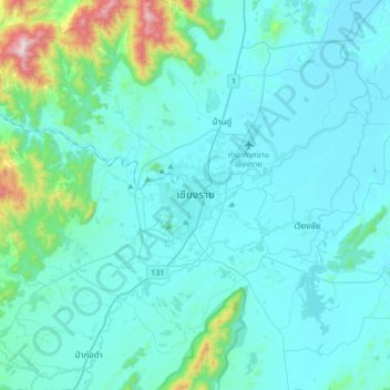
Name: Chiang Rai topographic map, elevation, terrain.

Location: Chiang Rai, Tha Sai, Chiang Rai Province, 57000, Thailand (19.74689 99.67327 20.06689 99.99327)

Average elevation: 473 m

Minimum elevation: 374 m

Maximum elevation: 1,313 m

Gear up for your next adventure:

🥾Trekking Poles - Adjustable trekking poles to reduce knee stress and improve stability
💡LED Headlamp - Hands-free illumination for night hiking and camping
🧦Crew Hiking Socks - Comfortable socks for long-distance hikes
🧢Outdoor Visor - Breathable visor for sunny hikes
🥾Trail Running Boots - Durable shoes designed for trail running

As an Amazon Associate, this site earns from qualifying purchases at no extra cost to you.