Geolocate

Fort Smith topographic map

Click on the map to display elevation.

About this map

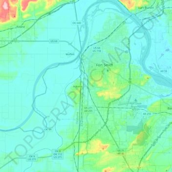
Name: Fort Smith topographic map, elevation, terrain.

Location: Fort Smith, Sebastian County, Arkansas, United States (35.25885 -94.43554 35.44982 -94.25286)

Average elevation: 142 m

Minimum elevation: 116 m

Maximum elevation: 300 m

Other topographic maps

Click on a map to view its topography, its elevation and its terrain.

Jenson

United States > Arkansas > Sebastian County

Average elevation: 177 m

Burna

United States > Arkansas > Sebastian County

Average elevation: 184 m

Gear up for your next adventure:

🥾Hiking Gaiters - Protect legs and shoes from mud, snow, and debris
🐕Hiking Dog Pack - Let your canine companion carry their own water and food
🧥Insulated Jacket - Keep warm in cold outdoor conditions
🧶550 Survival Paracord - Versatile utility cord for emergency repairs and rigging
💡Solar Camping Lamp - Eco-friendly lighting for campsites

As an Amazon Associate, this site earns from qualifying purchases at no extra cost to you.