Geolocate

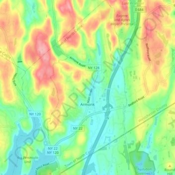
Armonk topographic map

Click on the map to display elevation.

Armonk

Situated 11 miles from the coast in the southeastern corner of New York, Armonk shares a border with Connecticut. The landscape is hilly and forested, with a mean elevation of 387 feet, and is home to the highest point in Westchester County with an elevation of 1,396 feet.

Wikipedia (CC-BY-SA 3.0)

About this map

Name: Armonk topographic map, elevation, terrain.

Location: Armonk, Town of North Castle, Westchester County, New York, 10504, United States (41.10034 -73.73374 41.16519 -73.69463)

Average elevation: 156 m

Minimum elevation: 107 m

Maximum elevation: 228 m

Other topographic maps

Click on a map to view its topography, its elevation and its terrain.

Gear up for your next adventure:

🚲MTB Frame Bag - Carry tools and maps directly on your bicycle frame
🧥Waterproof Jacket - Lightweight rain jackets for hiking and outdoor activities
🧭GPS Outdoor Watch - Smart watch for navigation and fitness tracking in nature
⛺Bushcraft Tarp - Versatile emergency shelter or gear protection
💧Hydration Bladder - Hands-free hydration solution for long treks

As an Amazon Associate, this site earns from qualifying purchases at no extra cost to you.