
Make a donation
Gear up for your next adventure:
As an Amazon Associate, this site earns from qualifying purchases at no extra cost to you.
Marco de Canaveses topographic map
Click on the map to display elevation.
Make a donation
Gear up for your next adventure:
As an Amazon Associate, this site earns from qualifying purchases at no extra cost to you.
Marco de Canaveses
The city of Marco Canaveses is strongly influenced by its topography, with mainly areas at altitudes between 200 and 600 meters, reaching the highest levels in Aboboreira and Montedeiras Mountains. The highest point of the county is situated at an altitude of 962 meters, in Aboboreira Mountain, which is shared by the municipalities of Marco de Canaveses, Amarante and Baião. In Montedeiras Mountain is reached a peak of 640 meters. To the north it lies the Marão Mountain, in the municipality of Amarante. The region is also traversed by two of the most important Portuguese rivers, the Douro river and Tâmega river. The Douro, reaching from "Trás-os-Montes" region (interior north of Portugal), east to west course, limits the county to the south, separating it from the municipalities of Cinfães and Castelo de Paiva. The Tâmega, north to south course, limits much of the County to the west, separating it from the Municipality of Penafiel. Another river that runs along the county is the Ovelha River, reaching from the Municipality of Amarante. The City of Marco de Canaveses is located 56 km away from Porto, 18 km away from Amarante, the 19 km away from Penafiel, 18 km away from Baião and 30 km away from Cinfães.
Make a donation
Gear up for your next adventure:
As an Amazon Associate, this site earns from qualifying purchases at no extra cost to you.
About this map
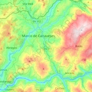
Name: Marco de Canaveses topographic map, elevation, terrain.
Location: Marco de Canaveses, Porto, Portugal (41.06418 -8.29298 41.25904 -8.04128)
Average elevation: 337 m
Minimum elevation: 9 m
Maximum elevation: 968 m
Make a donation
Gear up for your next adventure:
As an Amazon Associate, this site earns from qualifying purchases at no extra cost to you.
Other topographic maps
Click on a map to view its topography, its elevation and its terrain.
Make a donation
Gear up for your next adventure:
As an Amazon Associate, this site earns from qualifying purchases at no extra cost to you.
Make a donation
Gear up for your next adventure:
As an Amazon Associate, this site earns from qualifying purchases at no extra cost to you.
Santa Marinha do Zêzere
Portugal > Porto > Santa Marinha do Zêzere > Santa Marinha do Zêzere
Average elevation: 425 m
Make a donation
Gear up for your next adventure:
As an Amazon Associate, this site earns from qualifying purchases at no extra cost to you.
Make a donation
Gear up for your next adventure:
As an Amazon Associate, this site earns from qualifying purchases at no extra cost to you.
Make a donation
Gear up for your next adventure:
As an Amazon Associate, this site earns from qualifying purchases at no extra cost to you.
São Tomé de Covelas
Portugal > Porto > Santa Cruz do Douro e São Tomé de Covelas
Average elevation: 356 m