
Durbuy topographic map
Interactive map
Click on the map to display elevation.
About this map
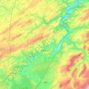
Name: Durbuy topographic map, elevation, terrain.
Location: Durbuy, Marche-en-Famenne, Luxembourg, Wallonia, Belgium (50.29898 5.34170 50.43061 5.63730)
Average elevation: 244 m
Minimum elevation: 106 m
Maximum elevation: 479 m
Other topographic maps
Click on a map to view its topography, its elevation and its terrain.
Harre
Belgium > Luxembourg > Marche-en-Famenne > Harre
Harre, Manhay, Marche-en-Famenne, Luxembourg, Wallonia, 6960, Belgium
Average elevation: 389 m
Marche-en-Famenne
Belgium > Luxembourg > Marche-en-Famenne > Marche-en-Famenne
Marche-en-Famenne, Luxembourg, Wallonia, 6900, Belgium
Average elevation: 252 m