Geolocate

Maheshtala topographic map

Click on the map to display elevation.

Maheshtala

Maheshtala is located at 22°30′31″N 88°15′12″E / 22.5086210°N 88.2532182°E / 22.5086210; 88.2532182. It has an average elevation of 9 metres (30 ft).

Wikipedia (CC-BY-SA 3.0)

About this map

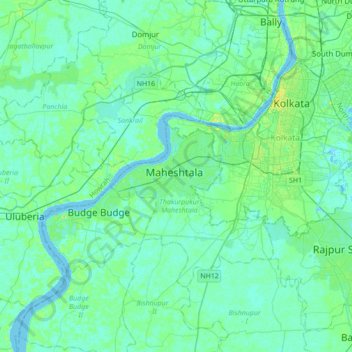
Name: Maheshtala topographic map, elevation, terrain.

Location: Maheshtala, Thakurpukur Maheshtala, South 24 Parganas District, West Bengal, 700141, India (22.34603 88.09017 22.66603 88.41017)

Average elevation: 5 m

Minimum elevation: -1 m

Maximum elevation: 25 m

Gear up for your next adventure:

🍽️Titanium Camping Spork - Ultralight and indestructible eating utensil
🥾Waterproof Hiking Boots - Boots keeping your feet dry in wet conditions
🛏️Sleeping Bag - Warm and compact sleeping bags for outdoor camping
🪑Insulated Seat Pad - Protect your seat from cold rocks and wet logs
🧰Survival Kit - Essential gear for emergencies in the wilderness

As an Amazon Associate, this site earns from qualifying purchases at no extra cost to you.