Geolocate

Taran topographic map

Click on the map to display elevation.

About this map

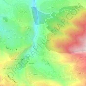
Name: Taran topographic map, elevation, terrain.

Location: Taran, Miniyeh-Danniyeh District, North Governorate, Lebanon (34.38659 36.01117 34.42659 36.05117)

Average elevation: 772 m

Minimum elevation: 413 m

Maximum elevation: 1,280 m

Gear up for your next adventure:

🧥Thermal Layer - Insulating layer for cold outdoor conditions
🥾All-Terrain Hiking Boots - Versatile boots for varied hiking conditions
🔦LED Headtorch - Bright and durable light for night activities
🥾Trail Running Shoes - Lightweight and durable shoes for trail running
🛁Quick-Dry Microfiber Towel - Space-saving towel that dries rapidly on the move

As an Amazon Associate, this site earns from qualifying purchases at no extra cost to you.