Geolocate

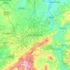
Guanhães topographic map

Click on the map to display elevation.

About this map

Name: Guanhães topographic map, elevation, terrain.

Location: Guanhães, Região Geográfica Imediata de Guanhães, Região Geográfica Intermediária de Governador Valadares, Minas Gerais, Southeast Region, 39740-000, Brazil (-19.09600 -43.06300 -18.61500 -42.54200)

Average elevation: 779 m

Minimum elevation: 335 m

Maximum elevation: 1,260 m

Other topographic maps

Click on a map to view its topography, its elevation and its terrain.
Itacarambi

Brazil > Minas Gerais > Itacarambi > Itacarambi

Average elevation: 455 m

Matas dos Correias

Brazil > Minas Gerais > Itabira

Average elevation: 932 m

Belo Horizonte

Brazil > Minas Gerais > Região Metropolitana de Belo Horizonte > Belo Horizonte

In 1893, due to the climatic and topographic conditions, Curral Del Rey was selected by Minas Gerais governor Afonso Pena among other cities as the location for the new economic and cultural center of the state, under the new name of Cidade de Minas, or City of Minas.

Average elevation: 904 m
Pico dos Dias

Brazil > Minas Gerais > Brazópolis

Average elevation: 1,520 m

Pico

Brazil > Minas Gerais > Santana do Riacho

Average elevation: 1,472 m

Serra do Chacrinha

Brazil > Minas Gerais > Itacambira

Average elevation: 1,166 m

Gear up for your next adventure:

⛺Lightweight Backpacking Tent - Compact tent for efficient hiking trips
🧥Softshell Jacket - Windproof and breathable jacket for hiking
🧼Travel Hand Sanitizer - Keep hands clean when water is scarce
🥾Mountain Trail Shoes - High-traction shoes for mountain trails
🥾Light Trekking Boots - Supportive boots for multi-day treks

As an Amazon Associate, this site earns from qualifying purchases at no extra cost to you.