Geolocate

Linares topographic map

Click on the map to display elevation.

About this map

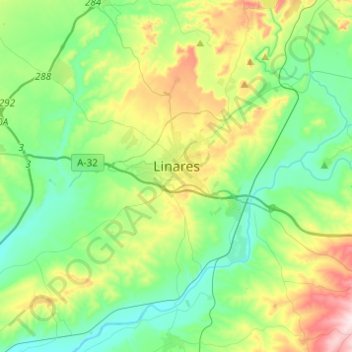
Name: Linares topographic map, elevation, terrain.

Location: Linares, Jaén, Andalusia, 23700, Spain (38.00217 -3.76205 38.17334 -3.51715)

Average elevation: 373 m

Minimum elevation: 243 m

Maximum elevation: 700 m

Gear up for your next adventure:

🧴Sunscreen SPF - Broad-spectrum sunscreen for outdoor activities
Camping Groundsheet - Protect your tent from moisture and dirt
🪑Insulated Seat Pad - Protect your seat from cold rocks and wet logs
🛌Down Sleeping Bag - Superior warmth-to-weight ratio for cold nights
🥾Mountain Trail Shoes - High-traction shoes for mountain trails

As an Amazon Associate, this site earns from qualifying purchases at no extra cost to you.