
Fairplay topographic map
Click on the map to display elevation.
Fairplay
The historic Town of Fairplay is the Statutory Town that is the county seat and the most populous municipality of Park County, Colorado, United States. The town population was 724 at the 2020 United States Census. Fairplay is located in South Park at an elevation of 9,953 feet (3,034 m). The town is the fifth-highest incorporated place in the State of Colorado. Fairplay is now a part of the Denver–Aurora–Lakewood, CO Metropolitan Statistical Area and the Front Range Urban Corridor.
About this map
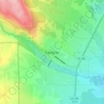
Name: Fairplay topographic map, elevation, terrain.
Location: Fairplay, Park County, Colorado, 80440, United States (39.21665 -106.01173 39.23388 -105.98102)
Average elevation: 3,040 m
Minimum elevation: 2,983 m
Maximum elevation: 3,150 m