Geolocate

La Possession topographic map

Click on the map to display elevation.

About this map

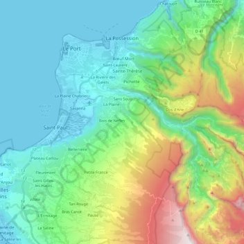
Name: La Possession topographic map, elevation, terrain.

Location: La Possession, Saint-Paul, Réunion, 97419, France (-21.09721 55.31908 -20.89563 55.46507)

Average elevation: 604 m

Minimum elevation: -1 m

Maximum elevation: 2,436 m

Gear up for your next adventure:

🥾Light Hiking Boots - Lightweight and comfortable boots for day hikes
🔦LED Headtorch - Bright and durable light for night activities
🥤Collapsible Travel Cup - Saves space and weight in your mess kit
🥾Hiking Leggings - Comfortable leggings for outdoor activities
🛁Quick-Dry Microfiber Towel - Space-saving towel that dries rapidly on the move

As an Amazon Associate, this site earns from qualifying purchases at no extra cost to you.