Geolocate

Torredembarra topographic map

Click on the map to display elevation.

About this map

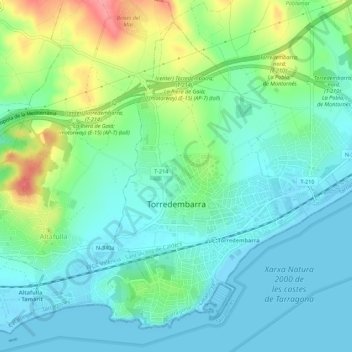
Name: Torredembarra topographic map, elevation, terrain.

Location: Torredembarra, Tarragonès, Tarragona, Catalonia, 43830, Spain (41.13157 1.38588 41.16728 1.44051)

Average elevation: 26 m

Minimum elevation: -2 m

Maximum elevation: 96 m

Other topographic maps

Click on a map to view its topography, its elevation and its terrain.

Salou

Spain > Catalonia > Tarragonès > Salou > Salou

Average elevation: 15 m

Parc del Fòrum

Spain > Catalonia > Tarragonès > Tarragona

Average elevation: 20 m

Gear up for your next adventure:

🎒Fully Waterproof Backpack - Total protection for photography gear and electronics
🧤Rechargeable Heated Gloves - Extreme warmth for Canadian winter expeditions
🧥Packable Rain Jacket - Breathable waterproof layer for unpredictable weather
🥾Hiking Gaiters - Protect legs and shoes from mud, snow, and debris
🛏️Sleeping Bag - Warm and compact sleeping bags for outdoor camping

As an Amazon Associate, this site earns from qualifying purchases at no extra cost to you.