
Srinagar topographic map
Click on the map to display elevation.
Srinagar
Under the Köppen climate classification, Srinagar has a four-season humid subtropical climate (Cfa) with hot summers and cool winters. The valley is surrounded by the Himalayas on all sides. Due to influence from the Himalayan rain shadow and western disturbances, Srinagar has year-round precipitation; the spring season is the wettest while autumn is the driest. Winters are colder than most areas with monsoon climates due to this and its elevation, with daily maximum temperatures averaging 7.1 °C (44.8 °F) in January, and dropping below freezing point at night. Moderate to heavy snowfall occurs in winter and the highway connecting Srinagar with the rest of India faces frequent blockades due to icy roads, landslides and avalanches. Summers are warm to hot with a July daytime average of 30.0 °C (86.0 °F). The average annual rainfall is around 697.5 millimetres (27.46 in).
About this map
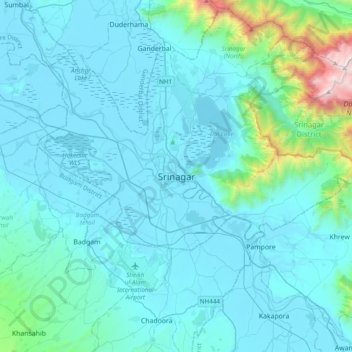
Name: Srinagar topographic map, elevation, terrain.
Average elevation: 1,805 m
Minimum elevation: 1,577 m
Maximum elevation: 4,024 m
Other topographic maps
Click on a map to view its topography, its elevation and its terrain.