Geolocate

Kyle topographic map

Click on the map to display elevation.

About this map

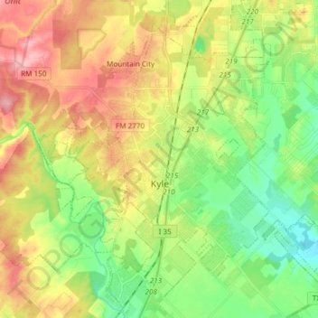
Name: Kyle topographic map, elevation, terrain.

Location: Kyle, Hays County, Texas, 78640, United States (29.94274 -97.97470 30.05550 -97.82502)

Average elevation: 221 m

Minimum elevation: 168 m

Maximum elevation: 290 m

Gear up for your next adventure:

Family Camping Tent - Spacious tent suitable for family camping trips
🛁Quick-Dry Microfiber Towel - Space-saving towel that dries rapidly on the move
🧢Hiking Hat - Sun-protective and breathable hats for long treks
🧥Thermal Fleece Jacket - Versatile insulation for changing mountain temperatures
🔦LED Headlamp - Hands-free lighting for early morning starts or late finishes

As an Amazon Associate, this site earns from qualifying purchases at no extra cost to you.