Geolocate

Leuven topographic map

Click on the map to display elevation.

About this map
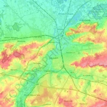
Name: Leuven topographic map, elevation, terrain.

Location: Leuven, Flemish Brabant, Flanders, Belgium (50.82421 4.64030 50.94407 4.77053)

Average elevation: 43 m

Minimum elevation: 4 m

Maximum elevation: 107 m

Other topographic maps

Click on a map to view its topography, its elevation and its terrain.
Leuven

Belgium > Flemish Brabant > Leuven > Leuven

Average elevation: 50 m

Bos

Belgium > Flemish Brabant > Leuven > Zoutleeuw

Average elevation: 31 m

Orsmaal

Belgium > Flemish Brabant > Leuven

Average elevation: 44 m

Optielt

Belgium > Flemish Brabant > Leuven > Tielt

Average elevation: 51 m

Butsel

Belgium > Flemish Brabant > Leuven > Boutersem

Average elevation: 66 m

Beneden-Kessel

Belgium > Flemish Brabant > Leuven > Leuven > Kessel-Lo

Average elevation: 34 m

Ourodenberg

Belgium > Flemish Brabant > Leuven > Aarschot

Average elevation: 16 m

Stadspark

Belgium > Flemish Brabant > Leuven > Aarschot

Average elevation: 24 m

Gear up for your next adventure:

🔦LED Headtorch - Bright and durable light for night activities
🐕Hiking Dog Pack - Let your canine companion carry their own water and food
🥫Freeze-Dried Meals - Lightweight, high-calorie nutrition for multi-day treks
🛌Insulated Sleeping Pad - Critical thermal barrier between you and the cold ground
🧢Hiking Hat - Sun-protective and breathable hats for long treks

As an Amazon Associate, this site earns from qualifying purchases at no extra cost to you.