
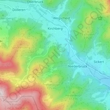
Kirchberg topographic map
Interactive map
Click on the map to display elevation.
About this map
Name: Kirchberg topographic map, elevation, terrain.
Average elevation: 614 m
Minimum elevation: 415 m
Maximum elevation: 1,059 m
Other topographic maps
Click on a map to view its topography, its elevation and its terrain.
Biederthal
France > Grand Est > Haut-Rhin
Biederthal, Altkirch, Haut-Rhin, Grand Est, Metropolitan France, 68480, France
Average elevation: 444 m
Hexenmatten
France > Grand Est > Haut-Rhin > Leymen
Hexenmatten, Leymen, Mulhouse, Haut-Rhin, Grand Est, Metropolitan France, 68220, France
Average elevation: 400 m
Le Bonhomme
France > Grand Est > Haut-Rhin
Le Bonhomme, Colmar-Ribeauvillé, Haut-Rhin, Grand Est, Metropolitan France, 68650, France
Average elevation: 904 m
Katzenthal
France > Grand Est > Haut-Rhin
Katzenthal, Colmar-Ribeauvillé, Haut-Rhin, Grand Est, Metropolitan France, 68230, France
Average elevation: 293 m
Ammerschwihr
France > Grand Est > Haut-Rhin
Ammerschwihr, Colmar-Ribeauvillé, Haut-Rhin, Grand Est, Metropolitan France, France
Average elevation: 325 m
Ribeauvillé
France > Grand Est > Haut-Rhin > Ribeauvillé
Ribeauvillé, Colmar-Ribeauvillé, Haut-Rhin, Grand Est, Metropolitan France, 68150, France
Average elevation: 395 m
Wettolsheim
France > Grand Est > Haut-Rhin > Wettolsheim
Wettolsheim, Colmar-Ribeauvillé, Haut-Rhin, Grand Est, Metropolitan France, 68920, France
Average elevation: 293 m
Zimmerbach
France > Grand Est > Haut-Rhin
Zimmerbach, Colmar-Ribeauvillé, Haut-Rhin, Grand Est, Metropolitan France, 68230, France
Average elevation: 353 m