
Make a donation
Gear up for your next adventure:
As an Amazon Associate, this site earns from qualifying purchases at no extra cost to you.
Bordj El Bahri topographic map
Click on the map to display elevation.
Make a donation
Gear up for your next adventure:
As an Amazon Associate, this site earns from qualifying purchases at no extra cost to you.
About this map
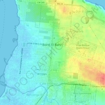
Name: Bordj El Bahri topographic map, elevation, terrain.
Location: Bordj El Bahri, Dar el-Beida District, Algiers, 16046, Algeria (36.77196 3.22890 36.80435 3.27134)
Average elevation: 18 m
Minimum elevation: -2 m
Maximum elevation: 57 m
Make a donation
Gear up for your next adventure:
As an Amazon Associate, this site earns from qualifying purchases at no extra cost to you.
Other topographic maps
Click on a map to view its topography, its elevation and its terrain.
The subdivision Mandariniers
Algeria > Algiers > Dar el-Beida District > Al Muhammadiyya > Pins Maritimes
Average elevation: 17 m
Bordj el Bahri Faizi
Algeria > Algiers > Dar el-Beida District > Bordj El Bahri
Average elevation: 19 m
The subdivision Mandariniers
Algeria > Algiers > Dar el-Beida District > Al Muhammadiyya > Pins Maritimes
Average elevation: 17 m
Make a donation
Gear up for your next adventure:
As an Amazon Associate, this site earns from qualifying purchases at no extra cost to you.
Résidence Le Badr
Algeria > Algiers > Dar el-Beida District > Bordj El Bahri > Cité 252 log
Average elevation: 14 m
Clos de car
Algeria > Algiers > Dar el-Beida District > Bordj El Bahri > Bordj el Bahri Faizi
Average elevation: 19 m