Geolocate

Gainesville topographic map

Click on the map to display elevation.

About this map

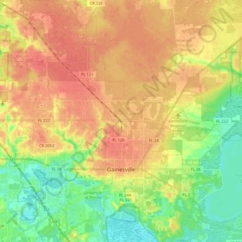
Name: Gainesville topographic map, elevation, terrain.

Location: Gainesville, Alachua County, Florida, United States (29.59786 -82.42225 29.77837 -82.22238)

Average elevation: 42 m

Minimum elevation: 16 m

Maximum elevation: 63 m

Other topographic maps

Click on a map to view its topography, its elevation and its terrain.

Earleton

United States > Florida > Alachua County

Average elevation: 46 m

Island Grove

United States > Florida > Alachua County

Average elevation: 18 m

Bland

United States > Florida > Alachua County

Average elevation: 44 m

Archer

United States > Florida > Alachua County > Archer

Average elevation: 25 m

Gear up for your next adventure:

🕶️Polarized Sunglasses - Reduces glare from snow and water at high elevations
🧭GPS Outdoor Watch - Smart watch for navigation and fitness tracking in nature
🧴Insect Repellent - Protect yourself from bugs during outdoor adventures
🧥Thermal Fleece Jacket - Versatile insulation for changing mountain temperatures
🥾Lightweight Hiking Shoes - Comfortable shoes for day hikes

As an Amazon Associate, this site earns from qualifying purchases at no extra cost to you.