
Make a donation
Gear up for your next adventure:
As an Amazon Associate, this site earns from qualifying purchases at no extra cost to you.
Dehradun topographic map
Click on the map to display elevation.
Make a donation
Gear up for your next adventure:
As an Amazon Associate, this site earns from qualifying purchases at no extra cost to you.
Dehradun
The city stands at an elevation of approximately 700 metres (2,300 ft) above sea level. Also known as the ‘Abode of Drona’, Dehradun has been an important centre for Garhwal rulers which was captured by the British. Often referred as the gateway to Mussorie. Uttarakhand Police is the main law enforcement agency in the city.
Make a donation
Gear up for your next adventure:
As an Amazon Associate, this site earns from qualifying purchases at no extra cost to you.
About this map
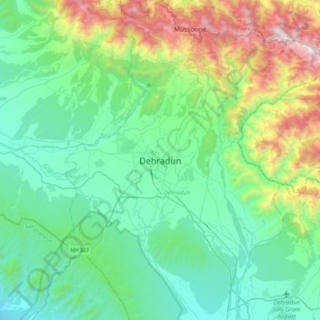
Name: Dehradun topographic map, elevation, terrain.
Location: Dehradun, Uttarakhand, 248001, India (30.16556 77.88368 30.48556 78.20368)
Average elevation: 904 m
Minimum elevation: 402 m
Maximum elevation: 2,568 m
Make a donation
Gear up for your next adventure:
As an Amazon Associate, this site earns from qualifying purchases at no extra cost to you.