Geolocate

Morillejo topographic map

Click on the map to display elevation.

About this map

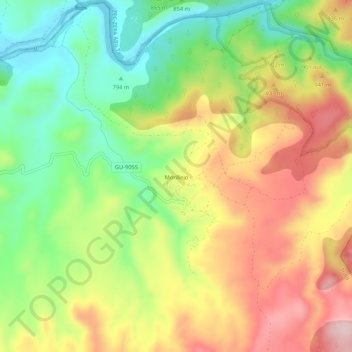
Name: Morillejo topographic map, elevation, terrain.

Location: Morillejo, Trillo, Guadalajara, Castile-La Mancha, Spain (40.66869 -2.49484 40.70869 -2.45484)

Average elevation: 875 m

Minimum elevation: 743 m

Maximum elevation: 1,026 m

Gear up for your next adventure:

🧢Sun Hat - Wide-brim hat for sun protection
🏃Hydration Running Vest - Carry water and maps close to your body for speed
🥫Freeze-Dried Meals - Lightweight, high-calorie nutrition for multi-day treks
🥾Trail Hiking Boots - Supportive boots for rough trails
🧥Insulated Jacket - Keep warm in cold outdoor conditions

As an Amazon Associate, this site earns from qualifying purchases at no extra cost to you.