
Make a donation
Gear up for your next adventure:
As an Amazon Associate, this site earns from qualifying purchases at no extra cost to you.
Alfenas topographic map
Click on the map to display elevation.
Make a donation
Gear up for your next adventure:
As an Amazon Associate, this site earns from qualifying purchases at no extra cost to you.
Alfenas
Alfenas is a municipality in the southern part of the Brazilian state of Minas Gerais. In 2020 its population was 80,494 and the area of the municipality is 849 km2. The elevation is 888m. It is served by highways MG 179, BR 491 and BR 369. The distance to the state capital of Belo Horizonte is 335 km and the distance to São Paulo is 300 km. The slogan for the city is "Alfenas, the gateway to the sea of Minas", in reference to nearby Lake Furnas.
Make a donation
Gear up for your next adventure:
As an Amazon Associate, this site earns from qualifying purchases at no extra cost to you.
About this map
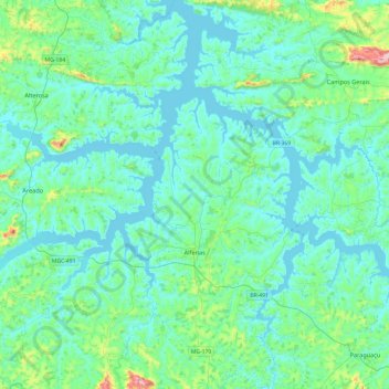
Name: Alfenas topographic map, elevation, terrain.
Average elevation: 827 m
Minimum elevation: 759 m
Maximum elevation: 1,271 m
Make a donation
Gear up for your next adventure:
As an Amazon Associate, this site earns from qualifying purchases at no extra cost to you.