Geolocate

Graham topographic map

Click on the map to display elevation.

About this map

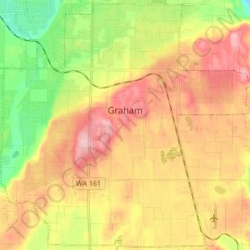
Name: Graham topographic map, elevation, terrain.

Location: Graham, Pierce County, Washington, United States (46.99442 -122.33889 47.07485 -122.21792)

Average elevation: 205 m

Minimum elevation: 109 m

Maximum elevation: 295 m

Gear up for your next adventure:

Camping Coffee Maker - Brew fresh coffee anywhere on the topographic map
🥽Outdoor Goggles - Protective eyewear for outdoor activities
🧴Insect Repellent - Protect yourself from bugs during outdoor adventures
👟Sport Hiking Sandals - Breathable footwear for water crossings and camp rest
🥾Hiking Gaiters - Protect legs and shoes from mud, snow, and debris

As an Amazon Associate, this site earns from qualifying purchases at no extra cost to you.