Geolocate

Great Falls topographic map

Click on the map to display elevation.

About this map

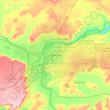
Name: Great Falls topographic map, elevation, terrain.

Location: Great Falls, Cascade County, Montana, United States (47.45799 -111.40747 47.55196 -111.19881)

Average elevation: 1,050 m

Minimum elevation: 952 m

Maximum elevation: 1,144 m

Gear up for your next adventure:

🔭Compact Monocular - One-handed bird watching and trail spotting
👟Leg Gaiters - Keep debris, mud, and snow out of your boots
🥘Camping Cookware Set - Compact nesting pots and pans for trail cooking
🧢Beanie Hat - Keep your head warm in cold weather
🥾Lightweight Hiking Boots - Boots for comfort and mobility on long hikes

As an Amazon Associate, this site earns from qualifying purchases at no extra cost to you.