
Grand Beach topographic map
Click on the map to display elevation.
About this map
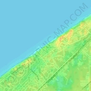
Name: Grand Beach topographic map, elevation, terrain.
Location: Grand Beach, Berrien County, Michigan, United States (41.76290 -86.80222 41.78482 -86.77511)
Average elevation: 183 m
Minimum elevation: 175 m
Maximum elevation: 202 m
Other topographic maps
Click on a map to view its topography, its elevation and its terrain.
Grand Mere State Park
United States > Michigan > Berrien County > Lincoln Charter Township
Average elevation: 185 m
Grand Mere State Park
United States > Michigan > Berrien County > Lincoln Charter Township
Average elevation: 185 m
Grand Mere State Park
United States > Michigan > Berrien County > Stevensville
Average elevation: 185 m
Grand Mere State Park
United States > Michigan > Berrien County > Stevensville
Average elevation: 185 m