
Make a donation
Gear up for your next adventure:
As an Amazon Associate, this site earns from qualifying purchases at no extra cost to you.
Woodland topographic map
Click on the map to display elevation.
Make a donation
Gear up for your next adventure:
As an Amazon Associate, this site earns from qualifying purchases at no extra cost to you.
About this map
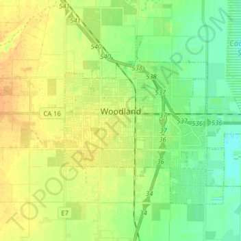
Name: Woodland topographic map, elevation, terrain.
Location: Woodland, Yolo County, California, United States (38.63760 -121.80276 38.70934 -121.68542)
Average elevation: 18 m
Minimum elevation: 5 m
Maximum elevation: 31 m
Make a donation
Gear up for your next adventure:
As an Amazon Associate, this site earns from qualifying purchases at no extra cost to you.
Other topographic maps
Click on a map to view its topography, its elevation and its terrain.
Make a donation
Gear up for your next adventure:
As an Amazon Associate, this site earns from qualifying purchases at no extra cost to you.
Davis
United States > California > Yolo County > Davis > Davis
Davis lies in the Sacramento Valley, the northern portion of the Central Valley, in Northern California, at an elevation of about 52 feet (16 m) above sea level.
Average elevation: 15 m
Make a donation
Gear up for your next adventure:
As an Amazon Associate, this site earns from qualifying purchases at no extra cost to you.