Geolocate

Walker topographic map

Click on the map to display elevation.

About this map

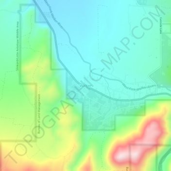
Name: Walker topographic map, elevation, terrain.

Location: Walker, Mono County, California, 96107, United States (38.49491 -119.49683 38.53491 -119.45683)

Average elevation: 1,736 m

Minimum elevation: 1,599 m

Maximum elevation: 2,056 m

Gear up for your next adventure:

🥾Trekking Poles - Adjustable trekking poles to reduce knee stress and improve stability
🔭Compact Monocular - One-handed bird watching and trail spotting
🔋Solar Power Bank - Keep your GPS and devices charged during long outdoor trips
🦌Outdoor Trail Camera - Monitor wildlife activity near your favorite spots
🪑Insulated Seat Pad - Protect your seat from cold rocks and wet logs

As an Amazon Associate, this site earns from qualifying purchases at no extra cost to you.