
Tours topographic map
Click on the map to display elevation.
About this map
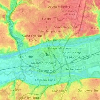
Name: Tours topographic map, elevation, terrain.
Average elevation: 73 m
Minimum elevation: 40 m
Maximum elevation: 116 m
Other topographic maps
Click on a map to view its topography, its elevation and its terrain.
La Feuillarde
France > Centre-Val de Loire > Indre-et-Loire > Saint-Pierre-des-Corps
Average elevation: 55 m
Le Clos des Chênes
France > Centre-Val de Loire > Indre-et-Loire > Chouzé-sur-Loire
Average elevation: 30 m
La Diablerie
France > Centre-Val de Loire > Indre-et-Loire > Chanceaux-sur-Choisille
Average elevation: 111 m
Le Grand Village
France > Centre-Val de Loire > Indre-et-Loire > La Ville-aux-Dames
Average elevation: 51 m
Le Télégraphe
France > Centre-Val de Loire > Indre-et-Loire > Chambray-lès-Tours
Average elevation: 86 m
La Diablerie
France > Centre-Val de Loire > Indre-et-Loire > Chanceaux-sur-Choisille
Average elevation: 111 m
Le Bois Turbet
France > Centre-Val de Loire > Indre-et-Loire > Marcé-sur-Esves
Average elevation: 82 m