
Make a donation
Gear up for your next adventure:
As an Amazon Associate, this site earns from qualifying purchases at no extra cost to you.
Ciudad Victoria topographic map
Click on the map to display elevation.
Make a donation
Gear up for your next adventure:
As an Amazon Associate, this site earns from qualifying purchases at no extra cost to you.
Ciudad Victoria
Ciudad Victoria has short mild winters and long hot summers. Temperatures rarely drop below 0 °C (32 °F) — the lowest recorded temperature was −6 °C (21 °F) and the hottest was 48.5 °C (119.3 °F), one of the highest temperatures ever recorded in Mexico. The average annual precipitation is 700 millimeters (28 in). Half of this amount falls between May and October, although there is a drying trend in the months of July and August. Its Köppen climate classification is BSh or Hot semi-arid, and its moderate elevation adds to overall precipitation pattern. Exceptionally heavy rains brought by occasional North Atlantic tropical cyclones also influence the overall climate and precipitation amounts.
Make a donation
Gear up for your next adventure:
As an Amazon Associate, this site earns from qualifying purchases at no extra cost to you.
About this map
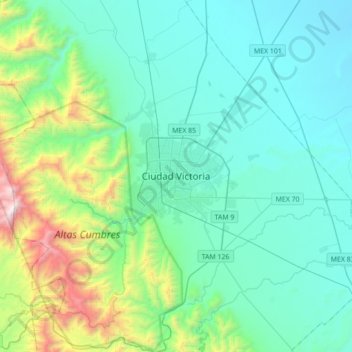
Name: Ciudad Victoria topographic map, elevation, terrain.
Location: Ciudad Victoria, Victoria, Tamaulipas, 87000, Mexico (23.57898 -99.30414 23.89898 -98.98414)
Average elevation: 518 m
Minimum elevation: 163 m
Maximum elevation: 2,149 m
Make a donation
Gear up for your next adventure:
As an Amazon Associate, this site earns from qualifying purchases at no extra cost to you.