Geolocate

Yumbo topographic map

Click on the map to display elevation.

Yumbo

Yumbo has a relatively dry but extremely foggy and sunless tropical savanna climate (Köppen Aw) not unlike the climate of Bogotá except substantially hotter due to the lower elevation.

Wikipedia (CC-BY-SA 3.0)

About this map

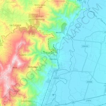
Name: Yumbo topographic map, elevation, terrain.

Location: Yumbo, Sur, Valle del Cauca, RAP Pacífico, 760501, Colombia (3.49025 -76.59781 3.69989 -76.42630)

Average elevation: 1,251 m

Minimum elevation: 937 m

Maximum elevation: 2,196 m

Other topographic maps

Click on a map to view its topography, its elevation and its terrain.

Río La Paila

Colombia > Valle del Cauca > Sevilla > Zarzal

Average elevation: 1,017 m

Villa Gorgona

Colombia > Valle del Cauca > Candelaria

Average elevation: 966 m

Charco Las Pilas

Colombia > Valle del Cauca > Cali

Average elevation: 1,197 m

Río Bolo

Colombia > Valle del Cauca > Pradera

Average elevation: 1,317 m

Quebrada Nueva

Colombia > Valle del Cauca > Quebrada Nueva

Average elevation: 1,111 m

El Billar

Colombia > Valle del Cauca > Ansermanuevo > El Billar

Average elevation: 1,697 m

Loboguerrero

Colombia > Valle del Cauca > Dagua

Average elevation: 865 m

Gear up for your next adventure:

🛶Waterproof Dry Bags - Keep electronics and clothes dry during river crossings
🔥Camping Stove - Portable stoves to cook outdoors with ease
🪑Ultralight Camping Stool - Compact seating for rest stops during long hikes
🥾Mountain Hiking Boots - High-traction boots for rocky terrain
Camping Tent - Weather-resistant tents suitable for 2 to 6 people

As an Amazon Associate, this site earns from qualifying purchases at no extra cost to you.