Geolocate

Cardiff topographic map

Click on the map to display elevation.

About this map

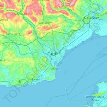
Name: Cardiff topographic map, elevation, terrain.

Location: Cardiff, Wales, CF10 2AF, United Kingdom (51.32165 -3.33919 51.64165 -3.01919)

Average elevation: 55 m

Minimum elevation: 0 m

Maximum elevation: 417 m

Other topographic maps

Click on a map to view its topography, its elevation and its terrain.

Dipping Pond

United Kingdom > Wales > Cardiff > Cardiff

Average elevation: 50 m

Gear up for your next adventure:

🧭GPS Outdoor Watch - Smart watch for navigation and fitness tracking in nature
🔋Lithium AA Batteries - Long-lasting power that performs in extreme cold
🧣Merino Neck Gaiter - Protects against wind, sun, and cold at high altitudes
💧Hydration Pack - Hands-free hydration system for long hikes
🕶️Polarized Sunglasses - Reduces glare from snow and water at high elevations

As an Amazon Associate, this site earns from qualifying purchases at no extra cost to you.