
Make a donation
Gear up for your next adventure:
As an Amazon Associate, this site earns from qualifying purchases at no extra cost to you.
Vladivostok topographic map
Click on the map to display elevation.
Make a donation
Gear up for your next adventure:
As an Amazon Associate, this site earns from qualifying purchases at no extra cost to you.
Vladivostok
Vladivostok has a monsoon-influenced humid continental climate (Köppen climate classification Dwb) with warm, humid and rainy summers and cold, dry winters. Owing to the influence of the Siberian High, winters are much colder than a latitude of 43 degrees should warrant, given its low elevation and coastal location, with a January average of −11.9 °C (10.6 °F). Winter temperatures are somewhat colder than Milwaukee and far colder than Florence; all 3 locations are at or above 43 degrees north latitude. They are even colder than those of Moscow and Minneapolis, interior locations at 56 and 45 degrees north, respectively. Since the maritime influence is strong in summer, Vladivostok has a relatively cold annual climate for its latitude.
Make a donation
Gear up for your next adventure:
As an Amazon Associate, this site earns from qualifying purchases at no extra cost to you.
About this map
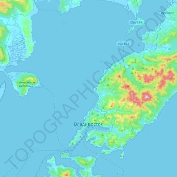
Name: Vladivostok topographic map, elevation, terrain.
Average elevation: 29 m
Minimum elevation: -3 m
Maximum elevation: 450 m
Make a donation
Gear up for your next adventure:
As an Amazon Associate, this site earns from qualifying purchases at no extra cost to you.