
Xining City topographic map
Interactive map
Click on the map to display elevation.
About this map
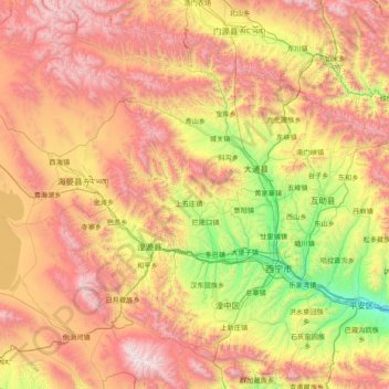
Name: Xining City topographic map, elevation, terrain.
Location: Xining City, Qinghai, China (36.22969 100.87031 37.46987 101.91223)
Average elevation: 3,215 m
Minimum elevation: 2,072 m
Maximum elevation: 4,799 m
Other topographic maps
Click on a map to view its topography, its elevation and its terrain.
Bahongxiatan
China > Qinghai > Huzhu Tu Autonomous County > Bahongcun
Bahongxiatan, Bahongcun, Huzhu Tu Autonomous County, Haidong City, Qinghai, China
Average elevation: 2,792 m