Geolocate

Visegrád topographic map

Click on the map to display elevation.

About this map

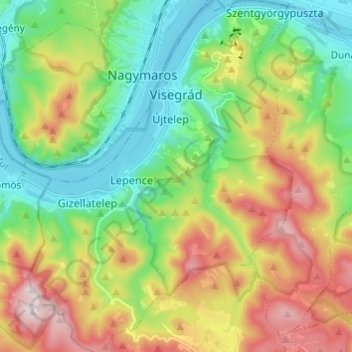
Name: Visegrád topographic map, elevation, terrain.

Location: Visegrád, Szentendrei járás, Pest, Central Hungary, Hungary (47.72471 18.91937 47.80635 19.01077)

Average elevation: 300 m

Minimum elevation: 99 m

Maximum elevation: 635 m

Other topographic maps

Click on a map to view its topography, its elevation and its terrain.

Danube

Hungary > Pest > Göd

Average elevation: 111 m

Dunakeszi

Hungary > Pest > Dunakeszi > Dunakeszi

Average elevation: 124 m

Gear up for your next adventure:

🧴Outdoor Sunscreen - High SPF protection for high-altitude UV exposure
🧴Insect Repellent - Protect yourself from bugs during outdoor adventures
Lightweight Camping Tent - Portable shelter optimized for Canadian backcountry camping
🎒Fully Waterproof Backpack - Total protection for photography gear and electronics
Family Camping Tent - Spacious tent suitable for family camping trips

As an Amazon Associate, this site earns from qualifying purchases at no extra cost to you.