
Thank you for supporting this site ❤️
Make a donation
Make a donation
Gear up for your next adventure:
As an Amazon Associate, this site earns from qualifying purchases at no extra cost to you.
Herrera topographic map
Click on the map to display elevation.
Thank you for supporting this site ❤️
Make a donation
Make a donation
Gear up for your next adventure:
As an Amazon Associate, this site earns from qualifying purchases at no extra cost to you.
About this map
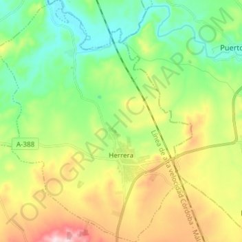
Name: Herrera topographic map, elevation, terrain.
Location: Herrera, Sevilla, Andalusia, 41567, Spain (37.33047 -4.91237 37.42731 -4.81452)
Average elevation: 240 m
Minimum elevation: 138 m
Maximum elevation: 418 m
Thank you for supporting this site ❤️
Make a donation
Make a donation
Gear up for your next adventure:
As an Amazon Associate, this site earns from qualifying purchases at no extra cost to you.