
Make a donation
Gear up for your next adventure:
As an Amazon Associate, this site earns from qualifying purchases at no extra cost to you.
Haverhill topographic map
Click on the map to display elevation.
Make a donation
Gear up for your next adventure:
As an Amazon Associate, this site earns from qualifying purchases at no extra cost to you.
Haverhill
According to the United States Census Bureau, the city has a total area of 35.6 square miles (92.3 km2), of which 33.0 square miles (85.4 km2) is land and 2.7 square miles (6.9 km2), or 7.47%, is water. The city ranks 60th in the Commonwealth in terms of land area, and is the largest city or town in Essex County. Haverhill is drained by the Little and Merrimack rivers, the latter separating the Bradford section of town from the rest of Haverhill. The highest point in the city is found on Ayers Hill, a drumlin with two knobs of almost equal elevation of at least 335 feet (102 m), according to the most recent (2011-2012) USGS 7.5-minute topographical map. The city also has several ponds and lakes, as well as three golf courses.
Make a donation
Gear up for your next adventure:
As an Amazon Associate, this site earns from qualifying purchases at no extra cost to you.
About this map
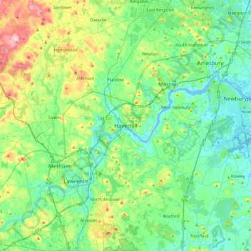
Name: Haverhill topographic map, elevation, terrain.
Location: Haverhill, Essex County, Massachusetts, 01830, United States (42.61778 -71.23677 42.93778 -70.91677)
Average elevation: 45 m
Minimum elevation: -5 m
Maximum elevation: 178 m
Make a donation
Gear up for your next adventure:
As an Amazon Associate, this site earns from qualifying purchases at no extra cost to you.