Geolocate

Sparks topographic map

Click on the map to display elevation.

About this map

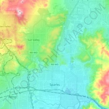
Name: Sparks topographic map, elevation, terrain.

Location: Sparks, Washoe County, Nevada, United States (39.51194 -119.78114 39.63835 -119.64975)

Average elevation: 1,438 m

Minimum elevation: 1,331 m

Maximum elevation: 1,784 m

Other topographic maps

Click on a map to view its topography, its elevation and its terrain.

Pleasant Valley

United States > Nevada > Washoe County

Average elevation: 1,587 m

Gear up for your next adventure:

🧦Crew Hiking Socks - Comfortable socks for long-distance hikes
🥾Hiking Leggings - Comfortable leggings for outdoor activities
Camping Tent - Weather-resistant tents suitable for 2 to 6 people
🥾Hiking Boots - Sturdy boots providing ankle support and traction on rugged trails
🔦LED Headtorch - Bright and durable light for night activities

As an Amazon Associate, this site earns from qualifying purchases at no extra cost to you.