
Make a donation
Gear up for your next adventure:
As an Amazon Associate, this site earns from qualifying purchases at no extra cost to you.
Ajaltoun topographic map
Click on the map to display elevation.
Make a donation
Gear up for your next adventure:
As an Amazon Associate, this site earns from qualifying purchases at no extra cost to you.
About this map
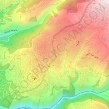
Name: Ajaltoun topographic map, elevation, terrain.
Average elevation: 723 m
Minimum elevation: 224 m
Maximum elevation: 1,137 m
Make a donation
Gear up for your next adventure:
As an Amazon Associate, this site earns from qualifying purchases at no extra cost to you.
Other topographic maps
Click on a map to view its topography, its elevation and its terrain.
Kfardebian
Lebanon > Keserwan-Jbeil Governorate
Kfardebian (Arabic: كفر دبيان; also spelled Kfar Dibiane and also known as Moucha'a Keserwan) is a municipality in the Keserwan District of the Keserwan-Jbeil Governorate in Lebanon. It is located 45 kilometers north of Beirut. Its average elevation is 1,220 meters above sea level and its total land…
Average elevation: 1,758 m