
Make a donation
Gear up for your next adventure:
As an Amazon Associate, this site earns from qualifying purchases at no extra cost to you.
Presicce-Acquarica topographic map
Click on the map to display elevation.
Make a donation
Gear up for your next adventure:
As an Amazon Associate, this site earns from qualifying purchases at no extra cost to you.
Presicce-Acquarica
Presicce-Acquarica is a municipality of 9.335 inhabitants, a population density of 217 people per km² and an altitude of 104 metres above the sea level.
Make a donation
Gear up for your next adventure:
As an Amazon Associate, this site earns from qualifying purchases at no extra cost to you.
About this map
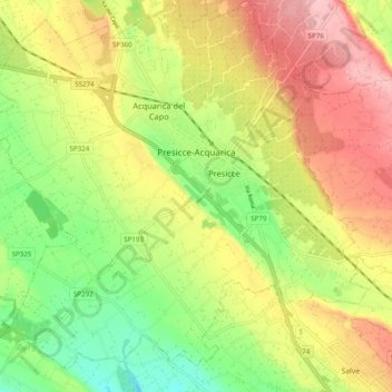
Name: Presicce-Acquarica topographic map, elevation, terrain.
Location: Presicce-Acquarica, Lecce, Apulia, Italy (39.85721 18.19983 39.93235 18.29761)
Average elevation: 123 m
Minimum elevation: 57 m
Maximum elevation: 191 m
Make a donation
Gear up for your next adventure:
As an Amazon Associate, this site earns from qualifying purchases at no extra cost to you.
Other topographic maps
Click on a map to view its topography, its elevation and its terrain.