Geolocate

Leonia topographic map

Click on the map to display elevation.

Leonia

While the borough center's elevation is 115 feet (35 m), the western part of the borough can reach 5 feet (1.5 m) and the eastern part of Leonia reaches 318 feet (97 m).

Wikipedia (CC-BY-SA 3.0)

About this map

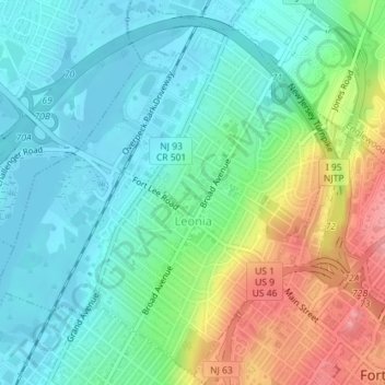
Name: Leonia topographic map, elevation, terrain.

Location: Leonia, Bergen County, New Jersey, 07605, United States (40.85088 -74.00628 40.87660 -73.97569)

Average elevation: 35 m

Minimum elevation: -1 m

Maximum elevation: 112 m

Gear up for your next adventure:

Camping Coffee Maker - Brew fresh coffee anywhere on the topographic map
🧴First Aid Kit - Essential first aid supplies for outdoor emergencies
🥾Hiking Gaiters - Protect legs and shoes from mud, snow, and debris
🥾Light Trekking Boots - Supportive boots for multi-day treks
🥾Trail Running Shoes - Lightweight and durable shoes for trail running

As an Amazon Associate, this site earns from qualifying purchases at no extra cost to you.