
Make a donation
Gear up for your next adventure:
As an Amazon Associate, this site earns from qualifying purchases at no extra cost to you.
Laketown Township topographic map
Click on the map to display elevation.
Make a donation
Gear up for your next adventure:
As an Amazon Associate, this site earns from qualifying purchases at no extra cost to you.
About this map
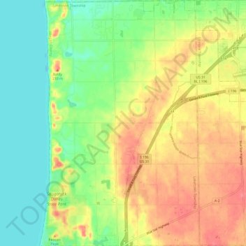
Name: Laketown Township topographic map, elevation, terrain.
Location: Laketown Township, Allegan County, Michigan, United States (42.68142 -86.21194 42.76834 -86.13491)
Average elevation: 202 m
Minimum elevation: 172 m
Maximum elevation: 237 m
Make a donation
Gear up for your next adventure:
As an Amazon Associate, this site earns from qualifying purchases at no extra cost to you.
Other topographic maps
Click on a map to view its topography, its elevation and its terrain.
Mount Baldhead
United States > Michigan > Allegan County > Saugatuck
Mount Baldhead, also known as Mt. Baldy and Radar Hill, is a 250-foot (76-meter) sand dune located on a narrow strip of land between Lake Michigan and Kalamazoo River, directly across the river from downtown Saugatuck. It has an elevation of 807 feet (246 meters) and is about 70 miles (110 kilometers) north of…
Average elevation: 184 m
Make a donation
Gear up for your next adventure:
As an Amazon Associate, this site earns from qualifying purchases at no extra cost to you.