
Make a donation
Gear up for your next adventure:
As an Amazon Associate, this site earns from qualifying purchases at no extra cost to you.
Puerto Williams topographic map
Click on the map to display elevation.
Make a donation
Gear up for your next adventure:
As an Amazon Associate, this site earns from qualifying purchases at no extra cost to you.
Puerto Williams
The climate of Puerto Williams is a temperate subpolar oceanic climate (Cfc) bordering closely on a tundra climate (ET) according to the Köppen climate classification. The summers are short and cool while the winters are long, wet, but moderate. Rainfall is around 512.3 mm (20 in) a year and temperatures are steady throughout the year. Snowfall can occur in summer. The cold and wet summers help preserve glaciers. Although the area around the town is well-forested, exposed areas at some distance from or altitude above it have a sub-Antarctic climate typical of tundra, which makes the growth of trees impossible.
Make a donation
Gear up for your next adventure:
As an Amazon Associate, this site earns from qualifying purchases at no extra cost to you.
About this map
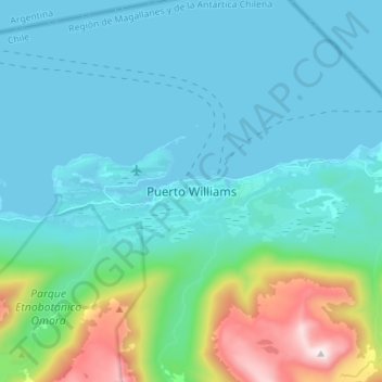
Name: Puerto Williams topographic map, elevation, terrain.
Average elevation: 151 m
Minimum elevation: 0 m
Maximum elevation: 898 m
Make a donation
Gear up for your next adventure:
As an Amazon Associate, this site earns from qualifying purchases at no extra cost to you.