
Make a donation
Gear up for your next adventure:
As an Amazon Associate, this site earns from qualifying purchases at no extra cost to you.
Ullapool topographic map
Click on the map to display elevation.
Make a donation
Gear up for your next adventure:
As an Amazon Associate, this site earns from qualifying purchases at no extra cost to you.
About this map
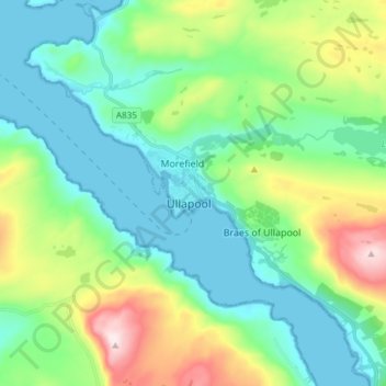
Name: Ullapool topographic map, elevation, terrain.
Location: Ullapool, Highland, Scotland, IV26 2XE, United Kingdom (57.85782 -5.19866 57.93782 -5.11866)
Average elevation: 150 m
Minimum elevation: 0 m
Maximum elevation: 575 m
Make a donation
Gear up for your next adventure:
As an Amazon Associate, this site earns from qualifying purchases at no extra cost to you.
Other topographic maps
Click on a map to view its topography, its elevation and its terrain.
Glen Coe
United Kingdom > Scotland > Highland > Glencoe
Habitats within Glen Coe include birch woodland, moorland and peatbogs. The upland parts of the glen are one of the best habitats for alpine and sub-alpine plants in Lochaber, due to the underlying geology and range of altitude. Typical plants found on the highest slopes of the glen include lady's…
Average elevation: 414 m
Make a donation
Gear up for your next adventure:
As an Amazon Associate, this site earns from qualifying purchases at no extra cost to you.