
Make a donation
Gear up for your next adventure:
As an Amazon Associate, this site earns from qualifying purchases at no extra cost to you.
Speichersdorf topographic map
Click on the map to display elevation.
Make a donation
Gear up for your next adventure:
As an Amazon Associate, this site earns from qualifying purchases at no extra cost to you.
About this map
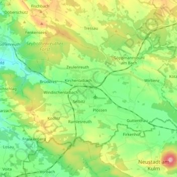
Name: Speichersdorf topographic map, elevation, terrain.
Location: Speichersdorf, Landkreis Bayreuth, Bavaria, 95469, Germany (49.83482 11.70750 49.90259 11.86194)
Average elevation: 483 m
Minimum elevation: 401 m
Maximum elevation: 652 m
Make a donation
Gear up for your next adventure:
As an Amazon Associate, this site earns from qualifying purchases at no extra cost to you.
Other topographic maps
Click on a map to view its topography, its elevation and its terrain.
Bad Berneck
Germany > Bavaria > Landkreis Bayreuth > Bad Berneck im Fichtelgebirge
Average elevation: 474 m
Make a donation
Gear up for your next adventure:
As an Amazon Associate, this site earns from qualifying purchases at no extra cost to you.
Make a donation
Gear up for your next adventure:
As an Amazon Associate, this site earns from qualifying purchases at no extra cost to you.