
Make a donation
Gear up for your next adventure:
As an Amazon Associate, this site earns from qualifying purchases at no extra cost to you.
Chikkaballapura topographic map
Click on the map to display elevation.
Make a donation
Gear up for your next adventure:
As an Amazon Associate, this site earns from qualifying purchases at no extra cost to you.
Chikkaballapura
The town of Chikkaballapur is approximately 56 km north of Bengaluru (formerly Bangalore) & Kolar city. Chikkaballapur has a high elevation located in the center of the Nandi Hills region. "Panchagiri" is a common descriptor of Chikkaballapur as it is surrounded by 5 picturesque hills among which Nandi Hills is the famous one (The five hills are known as Nandi Giri, Chandra Giri, Skandagiri, Brahma Giri, and Hema Giri). The Kalavara Halli hill Kalavaara betta, is becoming famous because of the trekking involved to reach the top of the hill. The north-south Six-lane National Highway NH-7 as well as the east–west NH 234 (previously state highway 58) goes through the city. The city is also a transportation hub comprising a new major bus terminus and train station headquarters. It is well connected to important towns by the state run buses as well as private taxis and autos. The nearest airport is Bengaluru International Airport at a distance of 30 kilometers. Nandi hills is also the birthplace of five rivers viz penneru chitravati south Paleru and other two.
Make a donation
Gear up for your next adventure:
As an Amazon Associate, this site earns from qualifying purchases at no extra cost to you.
About this map
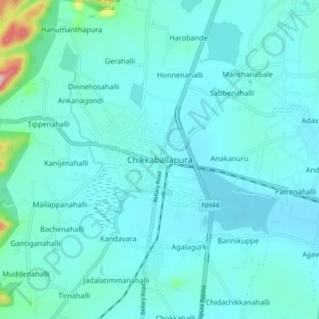
Name: Chikkaballapura topographic map, elevation, terrain.
Average elevation: 929 m
Minimum elevation: 894 m
Maximum elevation: 1,220 m
Make a donation
Gear up for your next adventure:
As an Amazon Associate, this site earns from qualifying purchases at no extra cost to you.