Geolocate

Tilbury topographic map

Click on the map to display elevation.

About this map

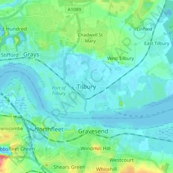
Name: Tilbury topographic map, elevation, terrain.

Location: Tilbury, Thurrock, England, RM18 8XR, United Kingdom (51.42312 0.32439 51.50312 0.40439)

Average elevation: 14 m

Minimum elevation: -6 m

Maximum elevation: 84 m

Gear up for your next adventure:

🧴Waterproofing Spray - Restore the DWR coating on jackets and tents
🔨Vehicle Emergency Tool - Safety tool for remote road trips to trailheads
🏃Hydration Running Vest - Carry water and maps close to your body for speed
🧢Outdoor Visor - Breathable visor for sunny hikes
🦟Insect Repellent - Keep mosquitoes and black flies away in wooded areas

As an Amazon Associate, this site earns from qualifying purchases at no extra cost to you.