
Make a donation
Gear up for your next adventure:
As an Amazon Associate, this site earns from qualifying purchases at no extra cost to you.
Villapourçon topographic map
Click on the map to display elevation.
Make a donation
Gear up for your next adventure:
As an Amazon Associate, this site earns from qualifying purchases at no extra cost to you.
About this map
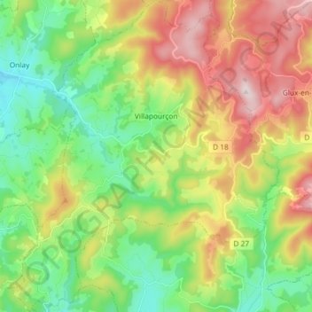
Name: Villapourçon topographic map, elevation, terrain.
Average elevation: 509 m
Minimum elevation: 292 m
Maximum elevation: 856 m
Make a donation
Gear up for your next adventure:
As an Amazon Associate, this site earns from qualifying purchases at no extra cost to you.
Other topographic maps
Click on a map to view its topography, its elevation and its terrain.
Champs de l'Avoine
France > Bourgogne-Franche-Comté > Nièvre > Fâchin > La Comme
Average elevation: 573 m
Nataloup
France > Bourgogne-Franche-Comté > Nièvre > Montsauche-les-Settons > Nataloup
Average elevation: 561 m
Clamard
France > Bourgogne-Franche-Comté > Nièvre > Brassy > L'Huis Bonnardin
Average elevation: 546 m
Make a donation
Gear up for your next adventure:
As an Amazon Associate, this site earns from qualifying purchases at no extra cost to you.