Geolocate

Volkach topographic map

Click on the map to display elevation.

About this map
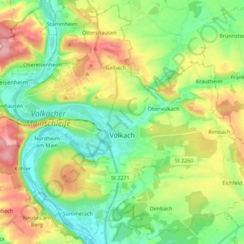
Name: Volkach topographic map, elevation, terrain.

Location: Volkach, Volkach (VGem), Landkreis Kitzingen, Bavaria, 97332, Germany (49.81891 10.16272 49.91605 10.31908)

Average elevation: 239 m

Minimum elevation: 187 m

Maximum elevation: 324 m

Other topographic maps

Click on a map to view its topography, its elevation and its terrain.
Euerfeld

Germany > Bavaria > Landkreis Kitzingen > Dettelbach

Average elevation: 276 m

Enheim

Germany > Bavaria > Landkreis Kitzingen

Average elevation: 290 m

Köhler

Germany > Bavaria > Landkreis Kitzingen > Volkach

Average elevation: 252 m

Langenberg

Germany > Bavaria > Landkreis Kitzingen

Average elevation: 399 m

Gear up for your next adventure:

🪑Insulated Seat Pad - Protect your seat from cold rocks and wet logs
🎒Hiking Backpack - Lightweight and ergonomic backpacks for day hikes or multi-day treks
❄️Traction Ice Cleats - Slip-on spikes for icy trails and winter hiking
🏃Hydration Running Vest - Carry water and maps close to your body for speed
⛺Bushcraft Tarp - Versatile emergency shelter or gear protection

As an Amazon Associate, this site earns from qualifying purchases at no extra cost to you.