Geolocate

Sotres topographic map

Click on the map to display elevation.

About this map
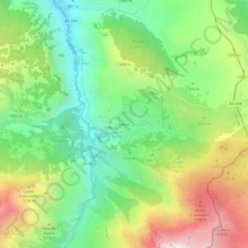
Name: Sotres topographic map, elevation, terrain.

Location: Sotres, Cabrales, Asturias, Spain (43.21308 -4.76922 43.25308 -4.72922)

Average elevation: 1,237 m

Minimum elevation: 720 m

Maximum elevation: 2,048 m

Other topographic maps

Click on a map to view its topography, its elevation and its terrain.

Bulnes

Spain > Asturias > Cabrales

Average elevation: 1,315 m

Bulnes

Spain > Asturias > Cabrales

Average elevation: 1,315 m

Sotres

Spain > Asturias > Cabrales

Average elevation: 1,496 m

Sotres

Spain > Asturias > Cabrales

Average elevation: 1,496 m

Arenas

Spain > Asturias > Cabrales

Average elevation: 670 m

Berodia

Spain > Asturias > Cabrales

Average elevation: 864 m

San Roque

Spain > Asturias > Cabrales

The altitude is 441 m (1,447 ft) above sea level. It is 20.87 km2 (8.06 sq mi) in size with a population of 199 (INE 2011). The postal code is 33555.

Average elevation: 737 m

Gear up for your next adventure:

🦶Anti-Blister Balm - Prevents friction and hotspots during long ascents
🐕Hiking Dog Pack - Let your canine companion carry their own water and food
🛌Down Sleeping Bag - Superior warmth-to-weight ratio for cold nights
🧥Insulated Jacket - Keep warm in cold outdoor conditions
🥾Hiking Gaiters - Protect legs and shoes from mud, snow, and debris

As an Amazon Associate, this site earns from qualifying purchases at no extra cost to you.